Snowmobile Tollgate, Oregon
Explore trail on map
#Tollgate
#BoneSprings
#JubileeLake
#Blues
Distance
Trailhead Altitude
Max. Altitude
Min. Altitude
Elev. Gain
Elev. Loss
Average Trail Slope
Max. Trail Slope

Trail Description

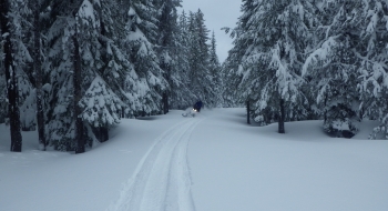
The gentle rolling terrain and flat ridge tops of the Blue Mountains provide good snowmobiling in the Tollgate area of Oregon. This area can really ramp up the snowfall too, with some of the highest snow depth totals in the region. There are several snopark options and groomed trails. Some of the areas can be densely forested where you must stay on the trail, but period open play areas and ongoing logging operations provide ample opportunity to break off the trail. Winter recreation can get very busy during weekends because it is one of the closest winter destinations for the population west of the mountains and there are thousands of vacation cabins around Tollgate.

Oregon Snopark Permits are required to park anywhere around Tollgate during winter months. These can be obtained from the Tollgate Store & Tavern or Spout Springs Ski Resort, but don't bank on either of these being open so it will be best to pick one up in your local town before your trip.

Our map here only includes a portion of the trail system. More will be added during Winter 2016-17.

Trail data mapped by Brian Sather on Apr 6, 2016 · Last update: Jan 6, 2018

Waypoints

Morning Creek Snopark — Oregon Snopark Permit required.

45.77479, -118.08288

Bone Springs CG play area

45.8939, -117.93997

Andies Prairie Snopark — Oregon Snopark Permit required.

45.70245, -118.03435

Woodland Snopark

45.73303, -118.03274

Video to Bone Springs area

45.84245, -117.94415

Video Snowmobiling — Includes Rough Fork Trailhead

45.804198, -118.046093

Play Area

45.79396, -118.02994

Swamp Creek Play Area

45.81619, -118.02966

Snowmobile Video

45.82662, -118.024178

Play Area — Road becomes a dead end

45.80221, -118.030025

Video of Powder Day Bone Springs

45.872484, -117.949791

Bald Mountain

45.77728, -118.045493

Tollgate Trailfinders Clubhouse

45.78525, -118.1099

Tollgate Store

45.78535, -118.10929

Plowed road for houses

45.78357, -118.1013

Spout boundary — Gate, difficult creek crossing at times, and high snowbank to parking lot. Non-motorized area so access Spout Parking from trail on other side of highway.

45.75945, -118.05505

Spout Springs Sno-park — Oregon sno-park permit required

45.75713, -118.05391

Video Coyote Loop

45.75662, -118.09281

Photos

In the Milk Shakes area near the Washington/Oregon border.Typical open play area.The different between deep snow and no snow is rather abrupt, looking down into the South Fork Walla Walla Canyon toward Harris Park.
Looking toward the Wenaha-Tucannon WildernessThe trail near Andies Prairie, mid storm.
Much of the road riding looks like this after a snowfall. South Fork of Walla Walla River from Bone Springs.There are several open boon dock areas that have some trees to navigate amongst.
Bone Springs Warming ShelterRough Fork Trail near Mottet can catch a lot of snow. See the buried toilet.