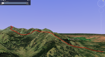
A 10k ski hike in the winter will have you topping out on Aneroid Summit from the Salt Creek Snowpark near Joseph, Oregon. The route here climbs Phat Ridge and then follows the southern aspect of the relatively popular backcountry skiing terrain of Wing Ridge. Note that the route goes down to the middle of the valley, which is a good open valley for limiting avalanche exposure, then gains the ridge south of the summit. The climb doesn't require much technical mountaineering because of its dome shape. However, expect some wind scouring on the south facing aspects of the mountain. The mountain can also be accessed from Wallowa Lake via the the Aneroid Lake trail, or possibly using it for a traverse? The snowpark features a nice warming hut for a place to sit and enjoy a fire (BYOW).
Directions to the start
- In Joseph, Oregon, follow Oregon State 350 for about 8 miles, then turn right onto Wallowa Loop Road (also known as the Hells Canyon Scenic Byway) and follow the road as it climbs up to the summit. The road is plowed up to the Sno-Park during the winter, but not beyond the Sno-Park.
Restrictions: Sno-Park Permit required.
Elevation at top: 9,707 ft.
Vertical gain: 4,587 ft
Weather: Check weather conditions and avalanche information from the Wallowa Avalanche Center as this is one of their primary places for snow study.

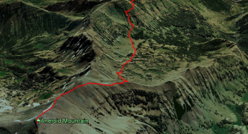
 to the ridge south of Aneroid Summit (looking west)")