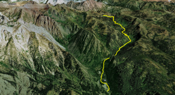
East Fork Pine Creek is a trail used by cows and cowboys that meanders through a burn near East Lakes Reservoir. This is featured as a downhill because that is the fun way to do it. How you get to the top is your business. The descending starts all the way at the top of the saddle, but we just show it here taking off from the Sugarloaf Trail. Some downed trees and erosion problems create some obstacles on the trail. It is an area that was burnt to a crisp in a wildfire circa 1990s. The bottom of the trail ends at an old mining road that crosses the East Fork. This road comes up from Cornucopia and officially is still the East Fork Trail. We only feature the singletrack here.
Trail Notes
- 0.0mi Start from Sugarloaf Trail and head downhill to the south. Trail 1865 also continues north into the wilderness.
- 4.0 Trail comes to the intersection with the mining road and your ford the East Fork.
- 5.1 Go around the gate that is the official trailhead and continue down the road through the private Cornucopia Lodge and cabins.
- 5.9. Arrive on the Cornucopia Highway, which is simply a gravel road that goes down to Halfway. Left will take you down the gravel road for a few miles to the pavement.