This downhill trail goes to the Wenaha River in the Wenaha-Tucannon Wilderness. Many huckleberries are along the trail particularly during the flatish middle section. Upon arriving at the river, the are 3-4 established camping areas on a flat meadow. There are a couple places to ford the river, which is basically a stream crossing in late summer. The Wenaha River Trail is on the other side, as well as several trails coming into it from the north including: Round Butte #3235, Sawtooth Ridge #3256, Dexter Ridge #3101, and Slick Ear Creek #3104.
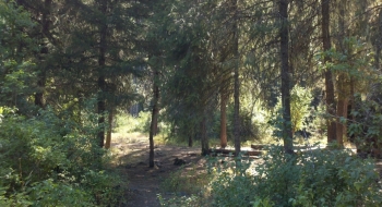
Trailhead: One official camp spot with a fire-ring and picnic table is located at the trailhead and numerous primitive camping is nearby. A bathroom is also at the trailhead. Road 62 is the main access road from either Troy, Elgin, or Tollgate. There currently is no sign marking the junction with Road 290, with accesses the trailhead. It is just a short way down Road 290.
Restrictions: NW Forest Pass required, Wilderness Regulations.


")