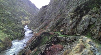
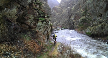
This ride lets you experience the rugged and punishing beauty of Hells Canyon. The difficulty starts with a long dirt road drive to the Imnaha River bridge that is doable, but not recommended, in a passenger car. The trail itself is one of the wider, more solidly constructed trails in the region but is littered with puncture weeds of all varieties. It is a strikingly beautify ride though, alongside the fast-flowing Imnaha River as it funnels through a deep gorge. You arrive at the Snake River 4.3 miles down the trail at a place called Eureka Bar, a defunct mining village. Then you can experience another 0.8 miles of fun trail down the Snake River. If you have made it this far with air still in your tires and no rattle snake bites, you may want to turn around and head back as to not press your luck. Or, if you want a massive climb on some unused trails to make a loop of it, read on.
At the 5 mile mark, there is a trail that heads up a canyon (Eureka Creek Trail). It looks good at first but quickly becomes more difficult to travel through weeds. Unfortunately this trail doesn't get much use. It climbs up to a clearing were there is an old abandoned cabin. From there, you can pick up a road that is a very scenic climb. At 8.6 miles after a sharp right hand hairpin that takes you west, there is a feint trail cutting off to the left. This trail is very primitive and hard to follow, but will largely trend downhill traversing the ridge down around some mines, gradually getting better before you are spit down onto a dirt road where you can descend down to the trailhead.
The trailhead does not include much fanfare or parking. It is just to the left before the bridge that crosses the Imnaha. There is a Fish & Game station there and some primitive camping on the other side of the bridge. Otherwise, there aren't many public camping spots in this area, as the riverfront is a mix of public and private land. This is a perfect ride for mountain bike fishing, and some of the local steelhead fisherman use bikes to get to the big ones.

 takes off from the road (right).")


 meets the Snake River. Note the jetboat that might spoil your remote feeling upon arrival.")
