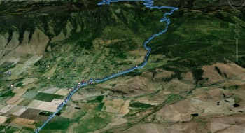
Mt. Fanny is a monstrous climb on a cross bike. If done properly from Phys Rd, the climb rises 4234 vertical feet in 19 miles, topping out at 7,123 at the summit. The road is steep only in a few places, but is otherwise a steady climb up to Moss Spring Campground. Then, the road gets rougher. In a few places, the road skirts the Eagle Cap Wilderness, offering a good view of the Wallowas.
Notes
- Take a right on French Road and head toward Moss Springs Campground.
- At Moss Springs Campground, take the road to the left to switch back up the southern part of Mount Fanny.
- After passing through some meadows where the road levels out, there will be a road to the left that goes up to the summit. There should be a radio tower sign marking this junction.