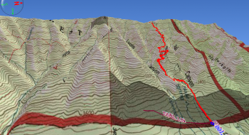
This is one of the few trails that connects the Grande Ronde Valley floor to the top ridge of the Blue Mountains. It is all climb, albeit fairly consistent and not terribly steep. At the lower end it is rocky and grown in. The middle section has some switchbacks before arriving at the ridge, where it stays in the trees as it travels to the top. The section near the top is usually grown in but only for a few hundred feet. Despite the low traffic this trail gets, it stays in fairly good condition.
The trail is accessed on Dial Lane in Summerville at the low end and Road 3120 (the road to Indian Rock) at the top. Both trail entries are unmarked.


. Note the trail on the bottom right.")