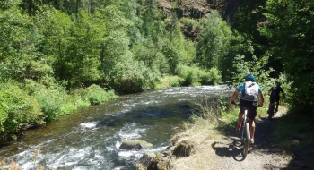
 One of the very few river-side mountain bike trails in the region, the South Fork Walla Walla provides a brutally awesome ride in rugged country. The trail offers up unique obstacles and some exposed riding atop short cliff walls over the river. The surface is certainly more unique and varied than the other fun trails in the Walla Walla River canyons. Several rocky sections will test your handling and wildlife will distract you often including moose and trail skunks. The trail starts at Deduct Pond, where bigfoot was famously documented in the Freeman Film, and continues downhill but it is physically challenging with a lot of undulations and steep climbs as the trail goes away from and back to the river several times. The river flows strong all year, but the spring time may cause some trail flooding.
The ride shown here starts near the headwaters and descends alongside the river the entire way to the popular Harris Park outside Milton-Freewater, Oregon. As it nears Harris Park, the trail becomes much wider and open, eventually joining and road off and on until arriving at the park. The incline is rarely steep in the lower sections as it follows the Walla Walla River very closely most of the time. Watch for hikers near the bottom because this is a very popular day use hike area especially on weekends. Did I say it is popular? If so, I'll say it again. It is also a moderately popular trail for motorbike riders, which I applaud (i.e. no trees on the trail).
See our EnterActive Map for this trail in the context of the entire system. The alternate exit/entry trail options include Bear Creek (4 miles from Harris Park); Burnt Cabin (5.5 mi) drops down from Tollgate; and Rough Fork (11.5 mi), comes down from near Jubilee Lake and Mottet Springs Campground.
To get to Deduct Pond Trailhead you'll have to drive a long ways on gravel up Mill Creek Road from Walla Walla. Harris Park is the easier access point for this trail so many will ride it up a ways and then back down. It is shown here in its entirety as a downhill ride for the biggest epic-effect. Harris Park is a day use area while overnight camping can happen at Deduct at the top.
Trail Notes
- 0.0mi. Deduct Pond Trailhead
- 7.1 Pass the Rough Fork Trail.
- 13.1 Pass Burnt Cabin Trail
- 14.6 Pass Bear Creek Trail which goes to Cub Saddle and Table Springs Trail and North Fork Walla Walla Trail.
- 17.5 Pass a place where you can ford the river and ride out the Elbow Canyon Climb.
- 18.9 Arrive at Harris Park.


.jpg "Trailhead on the upper end, at Deduct Pond.")
.jpg)


.jpg "A stream in late summer.")

