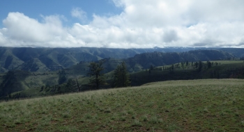
Rugged and scenic. Any trail I describe in the Hells Canyon area usually has those words, and Grizzly Ridge is no exception. While it is not a buffed fast singletrack, nor is it known by anyone as a mountain bike trail, it is a trail that keeps you on top of a ridge over expansive landscape that is well worth the bumping along cow and ATV trail. If it weren't for the ranchers and cattle this trail probably won't exist. It truly is a mix of doubletrack and singletrack after starting as a primitive road on Cayuse Flat. I was surprised the ridge was all rideable, at least out to the point where the Crooked Canyon Trail intersects. From there it starts to disappear and becomes very rough. It does continue along the ridge but I turned around where the track ends on this feature. There is where I also I confirmed that there is a feint trail down Crooked Canyon, although that didn't look rideable. However, if I'm ever down on the Horse Creek Trail it will be good to know I can climb up the mountain to this point and ride out this trail back to Cayuse Flat and the Hat Point Area.
Trail Description
Trail data mapped by Brian Sather on May 10, 2016 · Last update: Jun 23, 2016
Waypoints
Entrance gated — Sign say no motorized on private road.
45.52445, -116.76836Trailhead — There is no marking, parking, or distinction on this trailhead. A couple old fire rings exist. It starts right after crossing through the opening in the fence.
45.5064, -116.75737Corral — Trail disappears in the flat here, but picks up on the north end.
45.6165, -116.80351Trailhead Pumpkin Creek — There is a sign on the tree and the trail veers right off the primitive road.
45.55085, -116.76206Photos