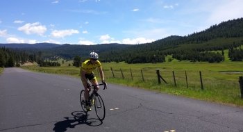
Not often can you ride a paved backcountry road with nearly no traffic that is almost spot-on a century distance. As a bonus, this hidden jewel of a loop is not far from La Grande but rarely done by anyone, on any vehicle. You will experience great views, challenging climbs, pristine meadows, streams, rivers, and older creepy men in mini-vans (these are basically scattered throughout the entire Elkhorn Mountains).
The loop is best done clockwise. From Starkey you start a long gentle climb up the Grande Ronde River before the big climb of Chicken Hill hits. This goes up to near 6,000' and is the highest point of the loop, so you have the big one out of the way. Descend to the intersection and take a right. Then, there are a series of relentless punchy climbs as you undulate your way along the ridge above the North Fork John Day River and Wilderness. Pearson Guard Station marks the final climbs before a long and fun descent to Ukiah on Soap Hill Road. After crossing a few dangerous cattle guards, the road suddenly becomes the best surface ever to deliver you down to Ukiah. From Ukiah you begin the shallowest, longest climb ever along Camas Creek all the way up to its headwaters and eventually the Blue Mountain Summit. Then it's all downhill except for an insulting little climb after Camp Elkhana.
Few to no services exist on this route. I mean this quite literally. Perhaps the Starkey Station Store will be open where you might start the ride and then there is nothing: no toilets, no snack shops, no beer, and no nothing until you get to Ukiah. You can get water at the Ranger Station there or some goods at the store or deli, but this is likely 4-5 or more hours into the ride. Between Ukiah and Starkey, again there is nothing but a couple campgrounds with vault toilets. There are plenty of streams along the road if you want to go raw.
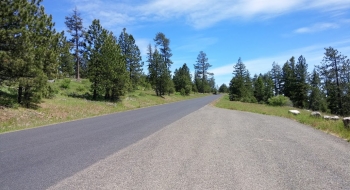
The loop circles a popular ATV trail system. The roads are rough chip seal with some cracks and potholes but overall roll pretty good. Much of these roads are closed during the winter but once they melt off you can experience the fun.